River information Saalach
The most important information about the Saalach at a glance
INFRASTRUCTURE
On the right side of the river in Au you will find developed parking spaces. A small fee of € 3,- has to be paid on site for the use of the infrastructure. Please park in such a way that the road can still be used by residents. You will find sanitary facilities and a snack bar on the left side at the entry point.
River passages
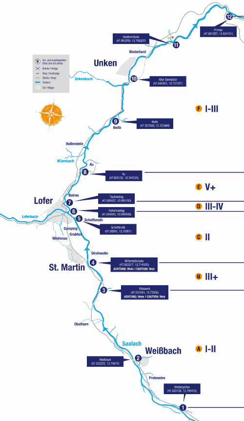
Ⓐ Upper Saalach
8 km WW I-II, ❶ Climbing garden – ❸ Gravel works
The Obere Saalach is the easiest section of the Saalach. It is ideal for beginners and can be used practically all year round.
Ⓑ St. Martin Gorge
2 km WW III +, ❸ Gravel works – ❹ Wildental Bridge
The Saalach becomes more challenging. The key point is the “corkscrew” shortly after the power station building, which, depending on the water level, reaches the fourth degree. Attention: because of the weir system at the gravel works, the water level is usually very low. It makes sense to embark directly above the corkscrew. After the short gorge there is a weir with a boat slide. VISIT BEFORE. There is a possibility of porting on the left bank.
Ⓒ Middle Saalach
3 km WW II, ❹ Wildental Bridge – ❻ Hubertussteg
The route runs past Camping Grubhof with a moderate degree of difficulty. At the end of the section, the Strubbach flows into the Saalach on the left.
Ⓓ World Championship slalom course
0.5 km WW III-IV, ❻ Hubertussteg – ❼ Teufelssteg
The World Championship slalom course offers great eddies and can be used on different lines. Navigable all year round in low water up to ”medium discharge“ ( Unterjettenberg level ca. 40m3/s, Weißbach level ca. 19-25 m3/s and water level indicator in the scale range 1 to a max. of 2), this section offers ideal, varied white water (WW III – IV). At water levels above mean-flow conditions the speed increases massively and the characteristics of the Saalach become much more apparent with a lot of press water. It is possible to exit at any time on to one of the hiking trails alongside the river. Mastery of the eskimo roll as well as solid technique are prerequisites for navigating the river.
Ⓔ Devil’s Gorge
2.5 km WW V +, ❼ Teufelssteg – ❽ Au
Very challenging. The level of difficulty changes depending on the water level from WW V to undrivable. The Devil’s Gorge should only be used by experienced kayakers. Lots of steps and cataracts await this section. Please visit it beforehand and pay attention to dangerous undermining and danger spots.
BEWARE OF LIFE DANGEROUS SIPHONS.
NOTE THE CURRENT RIVER INFORMATION.
Ⓕ Lower Saalach
15 km WW I-III, ❽ Au – ❶❷ Fronau
The first two kilometers to Au, the Saalach still attracts due to its incline and blockages, after which it becomes steadily quieter until the exit point in Fronau.
Exciting tributaries
Loferbach
6 km WW III-IV, bridge Loferer Bundesstrasse to the mouth. A wonderful overture to the Saalach, which is also a complete pleasure in itself. Good opportunity to warm up until the first weir (be careful!). Then the Loferbach rises to a lively staccato with a considerable gradient, which forces you to react quickly. Warning, danger from tree obstacles. Either get off at the small power station at the entrance to Lofer or continue paddling to the mouth (two weirs in the local area).
safety instructions
- With hard shell boats (eg canoes, kayaks, canoes, …) the Saalach can be used all year round. Please use the official entry and exit points.
- Driving on the Saalach with inflatable rowing vehicles is prohibited.
- The shipping signs (eg general driving ban at power plants, …) must be observed.
- Use of all river sections is at your own risk.
- The levels of difficulty relate to mean water level.
- General Information for sector D and E: The discharge information always refers to the water level measuring points at Unterjettenberg or Weißbach. The discharge values from the water gauges are only conditionally conclusive for navigation of the Teufelschlucht because there are some tributaries between the river section Loferschlucht and the water gauges. Therefore they can only serve as reference values in addition to your own, individual assessment, including inspection, on the day of the ride. Inspection on the day of the inspection. The water level indicator in the curve in front of the Teufelsteg is another aid for the paddler. The permanent change of the flow z. B. Attachment is not considered.
- In addition to the river information, you can find additional information about the water and waterlevel on our canoe cam and the water level indicator.
